Joan (Cowling)
Cowling
Friday, May 1, 2009 21:52 |
Cowling/Sutton/Glusburn boundary on crag front
Wonder if anyone knows of a map showing the boundary of Sutton/Cowling or even Glusburn/Cowling with footpaths on the front of the crag below Cowling (?)
Pinnacle please? Think this area is still privately owned. Got old ones, but not showing all paths. |
Paul Longbottom
Sutton
Saturday, May 2, 2009 19:30 |
Hello Joan,
The 25inch 1st edition OS of 1888-92 shows the paths you mention. It also shows the boundary quite clearly although the line remains undefined below the tower, very likley as a result of the problems encountered between Stott Hill and Sutton during the enclosure of the latter. |
Joan
Cowling
Sunday, May 3, 2009 19:18 |
Thanks v. much for the information Paul. |
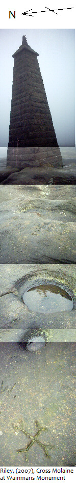
Sam Riley
Newton Rigg College
Wednesday, June 17, 2009 16:33 |
Paul, Joan
the early township boundary Cross Moline marks still appear on several rocks leading down the allotment bellow Wainmans Tower, the first is on a rock above the trilition stone - very hard to reach - you have to jump out over a 10ft deep split in the rocks from the boulder the monument stands on. then if you draw a line straight down the hill to Lane ends bridge you will see several large prominent boulders amongst the scree, two or three of these also bare Cross Moline, on their tops so some scrambeling is required.
From my extensive pawing over the old maps I am fairly sure the boundary runs to the west of the monument and runs between 200-300m parallel to current wall running down off the crag.
There may have been more marks in the past but the quarrying could have removed other stones. Anyone interested in industrial archeology may be able to spot the steam drill and older wedge splitting marks on some of the boulders as well.
Now Doris is gone I also feel I should pass on one of her favorite stories of the crag, that some of the stones from the quarrying activity in the area went to build Heysham Harbor (Not just sure if this was the harbor) and most of the tracks slip ramps and paths in the area were largely associated with the removal of stone.
The area is now open access - check the ordanance survey maps at http://www.ordnancesurvey.co.uk/oswebsite/getamap/
I have an image of the cross molaine with the tower which I will try to send to the webmaster, un-fortunately it was taken on a foggy day and would not fit on one image so have been digitaly stitched together.
yours
Sam Riley |
Paul Wilkinson
webmaster
Thursday, June 18, 2009 08:55 |
|
Joan
Cowling
Friday, June 19, 2009 21:05 |
Thanks v. much for that - Adrian mentioned a similar or the same cross at our Moonrakers Mtg., also another marking which I drew out. I will send you both a photo of another stone which is a puzzle- asap. Fossilized trees at Hitchingstone and Crag Delph - and was told another one found at Carleton - Crag Delph photo on Cowlingweb site,but will actually be in Sutton I think- have it here, would say c.1905?will send that also - some parts of tree still here in village. |

