Clerk
Tuesday, October 2, 2012 09:40 |
The Pinfold - Public Consultation
'Land on the East side of West Lane.'
The Pinfold or pound was situated up West Lane by the entrance to Stubbing Hill. It was a circular structure of stone some 6ft. in height and 10 yards in diameter. The pinder (pound keeper) during the late 19th century was Peter Petty, who besides rounding up animals was the local mole catcher.
At a Parish meeting held on the 30th June, 1896 permission was given to Mr J. W. Hartley 'that he be allowed to purchase all that plot of land containing 60 square yards bounded on the east by the highway leading from the village of Sutton to Arden, and on all other sides by a close of land the property of John William Hartley, the site
whereof was formerly used as a Pinfold of the Township. The sum agreed upon'. By March the following year the sale had been completed and the Pinfold demolished.
The land was bequeathed to the Parish Council in 1996.
The Parish Council has now received a request to purchase the land and is seeking the views of residents of Sutton-in-Craven.
The land is outside the development limits. Building would not be permitted.
|
Sylvia Dowgill
Sutton
Friday, October 5, 2012 19:02 |
Interesting to know who wants to buy it and for what reason ?
|
Andrew Monkhouse
Hanoi, Vietnam
Saturday, October 6, 2012 07:38 |
Could be a good opportunity for the Parish Council to use the proceeds to help local worthy causes, assuming the sale goes ahead. As for building not (currently) being permitted on the land........Thompson's Field! |
Clerk
Saturday, October 6, 2012 10:57 |
The resident who wants to buy the land lives very nearby and wants the land for
her children to run around in.
|
Sylvia Dowgill
Sutton
Monday, October 8, 2012 13:54 |
As a Sutton resident I am interested to know exactly where this piece of land is , there doesnt appear to be any opposite the entrance to Stubbing Hill. Have you a map / grid reference which can be made public please?
|
Paul Wilkinson
webmaster
Monday, October 8, 2012 16:45 |
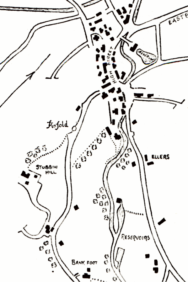
Click the link to download a map...
Pinfold field map
|
H Spence
Sutton
Monday, October 8, 2012 20:45 |
Have read the details given by the Clerk and looked at the map . "bounded on the east by the highway" and "by the entrance to Stubbing Hill." I thought entrance to Stubbing Hill was further down West Lane, or has the entrance altered also on map isn't the road on the west side not east. |
Clerk
Tuesday, October 9, 2012 05:12 |
Throughout the Parish Council minutes the land marked in red on the above map is referred to as the Pinfold.
I am informed that there was a stone croft and pump on the land and thus referred to as a Pinfold.
However I have now been informed that the Pinfold with the history written above was situated up West Lane by the entrance to Stubbing Hill on the right hand side.
The land marked in red on the above map is the land the Parish Council own and the land which is being requested to be purchased.
|
Paul Wilkinson
webmaster
Tuesday, October 9, 2012 08:17 |
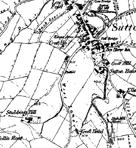
The 1840 and 1853 maps below show the location of the pinfold.
|
Nikki Barrett
Sutton
Tuesday, October 9, 2012 12:40 |
Call me Old fashioned but if this land was bequeathed to the Parish Council I feel this should remain so, I would imagine whoever left this land intended it to remain a safe area in the village and not for private use? A gift for the village?
Not being funny but the person who bought their property knew how much land they had.
I feel this should remain as part of the village, sorry if I have 'offended' anyone.
|
H Spence
Sutton
Tuesday, October 9, 2012 17:51 |
Thanks Clerk for clearing up my query. I'm with Nicky on this one, the person who bequeathed the land to the Parish Council obviously wanted the whole village to be able to enjoy it, not just one person to be able to up the value of their property by having a bigger garden. |
Brenda Whitaker
Queensland Australia
Tuesday, October 9, 2012 21:47 |
On the outside looking in - I wholeheartedly agree with Nikki - I did type something a few days ago and deleted it (being an outsider) however I feel that 'for children to play' is a nonsense, I would be very surprised if they dont already do that. |
Julian Hide
Sutton
Wednesday, October 10, 2012 08:39 |
I cannot see what use this land is to the village in its present state. If I had children of "playing-out" age I wouldn't want them playing there - it's semi-remote and being on the bend of an already narrow lane, which is quite well-used, I think that accessing the land would be dangerous. I would support the sale of the land with the proceeds being used somewhere more beneficial to general village use. |
Nikki Barrett
Sutton
Wednesday, October 10, 2012 09:45 |
Just to add to my statement we have been blessed with the most amazing Park in Sutton which is perfect for playing out, and is where I had to play when I was little.
I would be extremely hurt and upset if a member of my family bequeathed a piece of land to the village and in less than 20 years they sold it on for someones personal gain, the laws are safe at the moment for building but we never know what the future holds.
|
Paul Wilkinson
webmaster
Wednesday, October 10, 2012 13:03 |
I agree with those who oppose the sale, but more information about the intention when the land was bequeathed would help.
|
Clerk
Wednesday, October 10, 2012 17:33 |
I am doing some research into the matter and I will let you know of any information I find in due course. |
Samuel Riley
Newton Rigg College
Thursday, October 11, 2012 18:41 |
Pinfold � where is it?
Just to clarify there have been a couple of sites named pinfold on West lane, the ancient manorial pinfold was located where it is described on the historical maps at the bottom of the track to Stubbing Hill. This would have been manorial land that belonged to the Lord of the manor and later the parish council (or earlier equivalent) as it was a public pound used to contain escaped stock of commoners and freemen. The owners then had to pay a fine to the lord/Parish council to have their released from the pinfold, this was to prevent public nuisance and stock grassing land that did not belong to the stock owner.
I can clarify some of the sites older and more recent history however I am unsure who gave it back to the parish.
Enclosure of the Land
The land at Lane Top that is currently proposed for disposal from public owner ship has been called the pinfold, but is as I remember from Doris Riley�s teaching, this is not the historic site of a pinfold.
I think the land was originally in public ownership from the enclosure act of 1815. The land before the enclosure act sat right on the edge of the old enclosures and the open common fell. This can be clearly seen on the award map for the area. On the map the land appears to have been part of the open fell and is being enclosed as part of the act.
Incidentally this likely why the farm house is called Lane Top, as the enclosure map show it in existence on the very edge of the older enclosures i.e. where the lane through the fields stops the top of the hill, before the common hill grazing.
On the enclosure map the parcel of land is shown as part of the enclosure order. The ground has two field numbers allotted: 79, 67 (numbers are little unclear on the map so may be wrong).
On the key for the smaller allotments award, allotment 79 � (28 perches in size) appears to be awarded to the church. The writing after church become unclear on the scanned map, but there are two more words and the first looks like �Wardens� and then the third is illegible but may be �Pasture??? This is conjecture�.
Award 67 is tiny -6 perches (160 perches in an acre) and was allotted to W. R Sidwick Esq.
I am fairly confident on the field numbers as there are no other small allotment numbers that are similar to the number over the ground, that also appear on the small enclosures list ( the parcel definitely fits the small enclosures description). Given the other document evidence of Mr Hartley buying the land off the parish it would make sense for the church to be the original owner of the parcel after enclosure.
Recent History
When the land came back in to public owner ship in 1996, the land was given over to the conservation group for management, the top half of the site was planted with Christmas trees, for use around the village: sadly they were not harvested at the right age and now they are beyond use as Christmas trees.
The lower half the site was planted with more native species, a pond was dug and a shed erected to store equipment the group used to manage all the conservation site around the village. Unfortunately this was one of the groups last projects before it dissolved and the habitat has got rather out of control.
Just as a foot note to add more confusion there is also a third pinfold, identified on the Sutton Tithe Map (1841) (field No. 586) within the bounds of Sutton - only located miles away, two fields West of Crag End Farm, below Earls Crag!
Sam Riley
Lecture of Game and Wildlife Management
11/10/2012
Newton Rigg College (Askham Bryan College) |
Brenda Whitaker
Queensland Australia
Thursday, October 11, 2012 21:34 |
There seems to be a wealth of information being aired and it is wonderful to see/read - also the council should be commended for using a forum like this to both disseminate and gather local knowledge and opinion. So much better than hearing about it once it is a 'done deal'. Well done everyone, keep it up.
|
Marie Payling
Melbourne, Australia
Thursday, October 11, 2012 21:56 |
Like Brenda Whitaker I too am an outsider too, but the way land here is snapped up and built on here in Melbourne before you can turn around, this sound very "iffy" to me. The land was given to the Council and there is should stay for all Suttoners. Children play anyway and before you know it they are grown up and couldn't care less about running around on a plot of land - never heard anything so rediculous!!!
Marie Payling
Melbourne Australia |
Andrew Monkhouse
Hanoi, Vietnam
Friday, October 12, 2012 14:48 |
It seems nothing is sacred these days, every so often a museum will auction on eBay a whole heap of war medals bequeathed by individuals. Apparently once they are 'given' to the museum they become the property of the museum to do as they please, which includes thinning out stock from time to time.
It's the same with land, here in Adelaide a beautiful area of land near the promenade previously bequeathed for the benefit of the public was recently sold off to a building developer after a series of 'alleged' back-handers secured the sale. No names mentioned but the local mayor was not re-elected after the public outcry!
So here we have the Pinfold also bequeathed to the village up for debate. Will it or won't it? If it sells then people may think twice about bequeathing land/property in the future. Just my thoughts. |
Caspar Lucas
sutton-in-craven
Monday, October 15, 2012 21:10 |
As the individual who has expressed an interest in purchasing the area of land known as the "Pinfold" ,I would like to clarify the situation as regards to our intentions 'if' the parish council decides to sell the land.
The area of land in question is approximately 0.1 hectares in area, and is planted with a mixture of deciduous and coniferous trees, with a small area of rough grass, additionally there are two wooden sheds which are both in a state of disrepair.
It appears that the conifers were planted approximately 15-20 years ago, but have not been thinned and are now growing too close together, resulting in die back of the lower branches.
If we do puchase the land it would be my intention to:
1)Remove a number of the conifers thereby giving the remaining trees more space.
2)clear overgrown undergrowth and generally manage the area.
i would also like to state that we do not have any plans to build on the land, and that our interest is just to manage and use it for pleasure.
I understand the issues with the land being bequeathed, but surely it is better for the village to get some benefit from it, rather than just leave it with no purpose?
Additionally it must be appreciated that the land has to be managed by the parish and this must have an ongoing cost.
|
David Laycock
Tuesday, October 16, 2012 12:09 |
As I see it, if land was bequeathed to the council for the use of the village , then it must remain the property of the village, untill such a time as the rate payers of Sutton make a decision (through the council) to do otherwise.
It is a good sign that Mr. Lucas is willing to discuss his proposal with the public. Could he be allowed to lease it, subject to certain conditions which would safeguard it for the future?
As Brenda mentioned we are outsiders but still retain an interest in the village's day to day events.
Marie, where in Melbourne are you? |
Marie Payling
Melbourne, Australia
Tuesday, October 16, 2012 23:14 |
Hi David, I live in Briar Hill just around the corner from Eltham and have done for 30 years. My association with Sutton is from younger days. Mary Pearce (married to Jimmie Pearce) was my mother's sister and I spent many happy holidays there and have wonderful memories of Sutton and always will have. I try to get there just for a walk down memory lane when I am in England.
Keep Sutton for Suttoners, everything is disappearing all over the World and not for the best.
Marie Payling
Melbourne, Australia |
Camille Askins
Sutton-in-Craven
Wednesday, October 17, 2012 06:56 |
Caspar if these are your intentions then why do you need to buy the land? It has been managed before, by the conservation group. You could organise another group and do this work for the good of the village? |
Tony Ingham
Sutton
Wednesday, October 17, 2012 08:29 |
To the best of my knowledge, as told by Mr Ted Lister late of Bankfoot Farm, the land now known as Pinfold was given to the Village by John W. Hartley in order to straighten the bend in the road on West Lane. Presumably, this was not done because its removal would have meant that traffic speed would have greatly increased. |
Paul Wilkinson
webmaster
Wednesday, October 17, 2012 08:33 |
That's a great suggestion Camille.
|
Julian Hide
Sutton
Wednesday, October 17, 2012 14:53 |
Accepting all that is said above, I stick with my earlier post that the land can be sold. I'm sure that Tony is correct in saying that the original intention was to straighten the bend, hence the shape of the plot. However, I can't see the Highways Authority ever doing that - they can't even trim the overgrowth along the sides of West Lane lower down where I frequently scratch the near side of my car thanks (usually) to some prat in a Range Rover who doesn't know how to slow down. (What time is my anger management course?)
Assuming that there is no covenant in the transfer deed prohibiting the sale of the land, I still support its sale to Mr Lucas, who no doubt has a wood-burning stove. (Cynical....me?). In its present state it is of no use whatever to the village, and even cleared of foliage would still be of minimal use - as I said above, access is bad to the extent of being dangerous, and I cannot for the life of me see it being used.
It makes more sense to sell it at current market value, including timber, and use the funds for eg future improvements in the park where it can be of value to the whole village. |
Janet Hargreaves
Harrogate
Wednesday, October 17, 2012 15:07 |
I feel Tony may well be correct. Ted Lister would be the person who would know the thinking behind the donation as I seem to recall that he used to look after the Pinfold when I lived on the Tops.
However good intentioned Casper is, in my opinion this land should be kept in Public ownership. It was given to the Village. I am sure that if it had not been intended to be used for the benefit of Village Mr Hartley would have sold/donated it to specific landowners eg Bankfoot.
I second the comments by Camille. Perhaps I might suggest that if Casper is concerned about the land and wants to see it put to good use he could rally the residents together and set up a Voluntary Conservation project on behalf of the village? This piece of land and others further up the hill are all good wildlife habitats where blackberries/bilberries used to grow in abundance. A project along these lines would enable the land to remain public, it would bring like minded villagers together and it would be good for the environment.
I cannot see how this can be regarded as a suitable piece of land for 'pleasure pursuits' by unsupervised children because of it's dangerous location i.e the road is narrow and the corner blind? |
Nikki Barrett
Sutton
Friday, November 16, 2012 12:12 |
Just read the article in the Craven herald regarding the Pinfold, I just wanted to express my gratitude to the Parish Council for refusing the sale of the land. Good decision! |
Brenda Whitaker
Queensland Australia
Friday, November 16, 2012 21:01 |
Sanity has prevailed - well done. |

